Drones Spot Swarms of Sharks Around Stunning Island
A high-tech project provides new scientific insight into a Seychelles atoll.
A team of drone pilots has made an unusual, crystal clear map of a protected coral atoll that scientists are now using to count sharks and turtles and measure the physical changes of the shifting sands.
The maps were made by flying drones low over the St. Joseph atoll in the outer Seychelles, a 10 square-mile (25 square-kilometer), uninhabited island that was designated as a protected marine reserve in July 2014. A small team from the Switzerland-based nonprofit group Drone Adventures spent a week flying their drones over the area, with support from the Geneva-based nonprofit Save Our Seas Foundation.
"Drones are an amazing tool for research," says Michael Scholl, the CEO of Save Our Seas. "You can get good baseline maps for research and count and study animals without disturbing them."
The above map of the atoll provides higher resolution and a clearer view than anything from a satellite, yet it was cheaper to make than using an airplane or helicopter. (Learn more about efforts to restore the Seychelles.)
Still, it was a challenging project.
Drone Adventures had worked in Africa but had never tried their drones over the ocean before.
"That comes with its own set of issues, like sun reflection and a lack of features in the water [like landmarks]," says Scholl. "And no drones are compatible with seawater."
Mapping from the Sky
Over a week in late November, the team tested three approaches, to get three different sets of data.

First, they made systematic passes of the whole atoll with their fixed-wing, pro mapping-grade eBee drones, then they stitched the resulting digital images together. That produced a gorgeous high-resolution map (and a complementary 3D model) of the island, which scientists will use to study changes in sea level, the reef, and vegetation. The software removed any moving objects that had passed between the drones and the island in order to provide the highest image clarity. The map is so accurate, you can geolocate any spot on the atoll with a precision of 12 inches (30 centimeters).
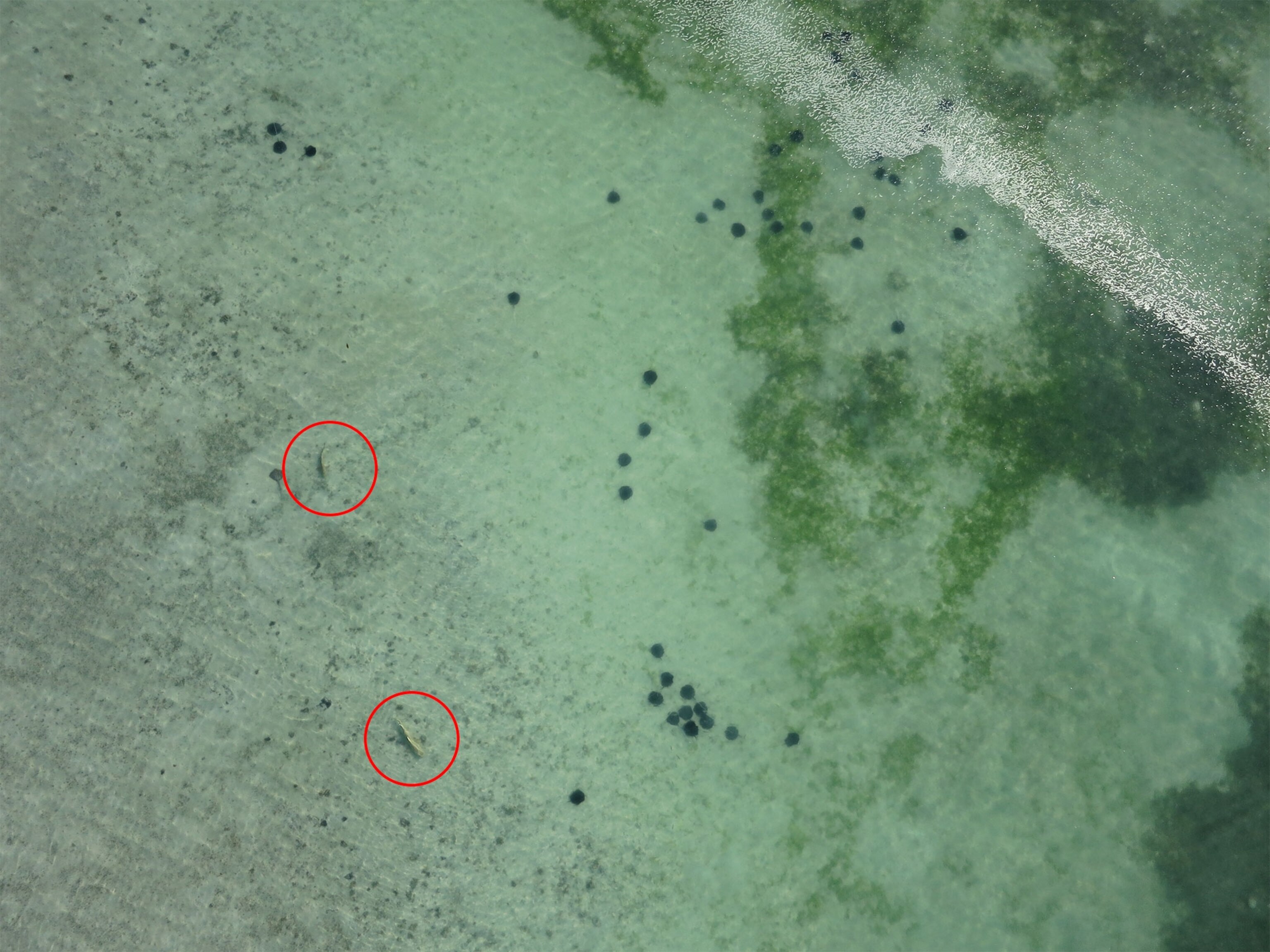
Next, the team flew drones even lower above the surrounding waters, about 160 feet (50 meters) above the waves. These images reveal a rich abundance of lemon and black tip sharks, sea turtles, and sting rays. Scientists are currently poring over the images, but early analysis suggests an encouraging number of young sharks in the lagoon, Scholl says.
Finally, the team tried flying a thermal camera over the beach to look for buried turtle eggs, but the drones' "eyes" were unable to penetrate the sand.
By looking at the map, it's already apparent that rising water is killing some of the trees on the island, says Rainer von Brandis, the scientific director of the Save Our Seas Foundation's D'Arros Research Centre. Brandis is currently leading an effort to restore some of the native broadleaf plants on the island that had been disturbed by human activity. He'll use the images to gauge the progress. Over the next few decades, even more dramatic changes are possible on the island, Brandis notes, such as changes in the reefs and the opening of a deep channel through the middle of the atoll.
The drone mapping provided a low-impact way to study the fragile atoll ecosystem, which scientists will be monitoring over the coming years.
"We left the atoll overly happy," the Drone Adventures team wrote on their blog, "with the satisfaction that we could bring answers to questions such as 'can one map an atoll with drones' or 'is drone imagery good enough to spot animals in marine transects and research areas,' having lots of fun on top of it.
Follow Brian Clark Howard on Twitter and Google+.


