Mapping the Hidden Worlds Beneath Greenland’s Ice
New technology is helping scientists look into and underneath Greenland’s massive ice sheet, uncovering important clues to future sea level rise.
The massive chunk of ice covering Greenland accounts for around 10 percent of the frozen freshwater on Earth. If all that were to melt, it could raise the global sea level more than 20 feet (6 meters).
To understand the future of all that ice, scientists are peering into its past. Using the latest technology to map what’s hidden beneath—and within—Greenland’s ice, researchers have found huge ancient river systems, unexpected ice flow, and troubling melting patterns.
Much of the latest research on the island’s ice sheet has been based on data from NASA’s Operation IceBridge, a decade-long airborne survey of Earth’s polar ice. Since 2008, planes carrying loads of cutting-edge instruments—including ice-penetrating radar—have been flying over Antarctica and Greenland for two months of every year. The resulting data is revealing all sorts of things about the ice and the landscapes beneath it.

One of the latest results of this research is the new map pictured above. It depicts the ground below Jakobshavn Glacier, Greenland’s largest outlet glacier and one of the fastest flowing glaciers on Earth. The study, published in Geophysical Research Letters in June, reveals an extensive network of ancient rivers. These rivers predate Greenland's ice sheet by more than three million years and once drained a region that's about the size of the Ohio River basin.
Some of those river channels were more than 7 miles (11 kilometers) wide and 4,500 feet (1.3 kilometers) deep. While that’s not as big as the Grand Canyon—which reaches 18 miles (29 kilometers) wide and more than 6,000 feet (1.8 kilometers) deep—it is bigger than a megacanyon discovered beneath Greenland’s ice in 2013. They determined this using a digital elevation model based on ice-penetrating radar.
The river channels are V-shaped, indicating they were carved by rivers, and not by glaciers, which leave U-shaped valleys behind. Greenland is largely made of a hard metamorphic rock called gneiss, so it likely took the rivers more than two million years to make the channels. The researchers think the landscape has had minimal erosion from the ice sheet and probably looks a lot like it did before the ice formed.
The research also shows that ice flows faster above the bigger channels. Mapping the landscape below helps scientists better understand how the ice above will behave in the future.

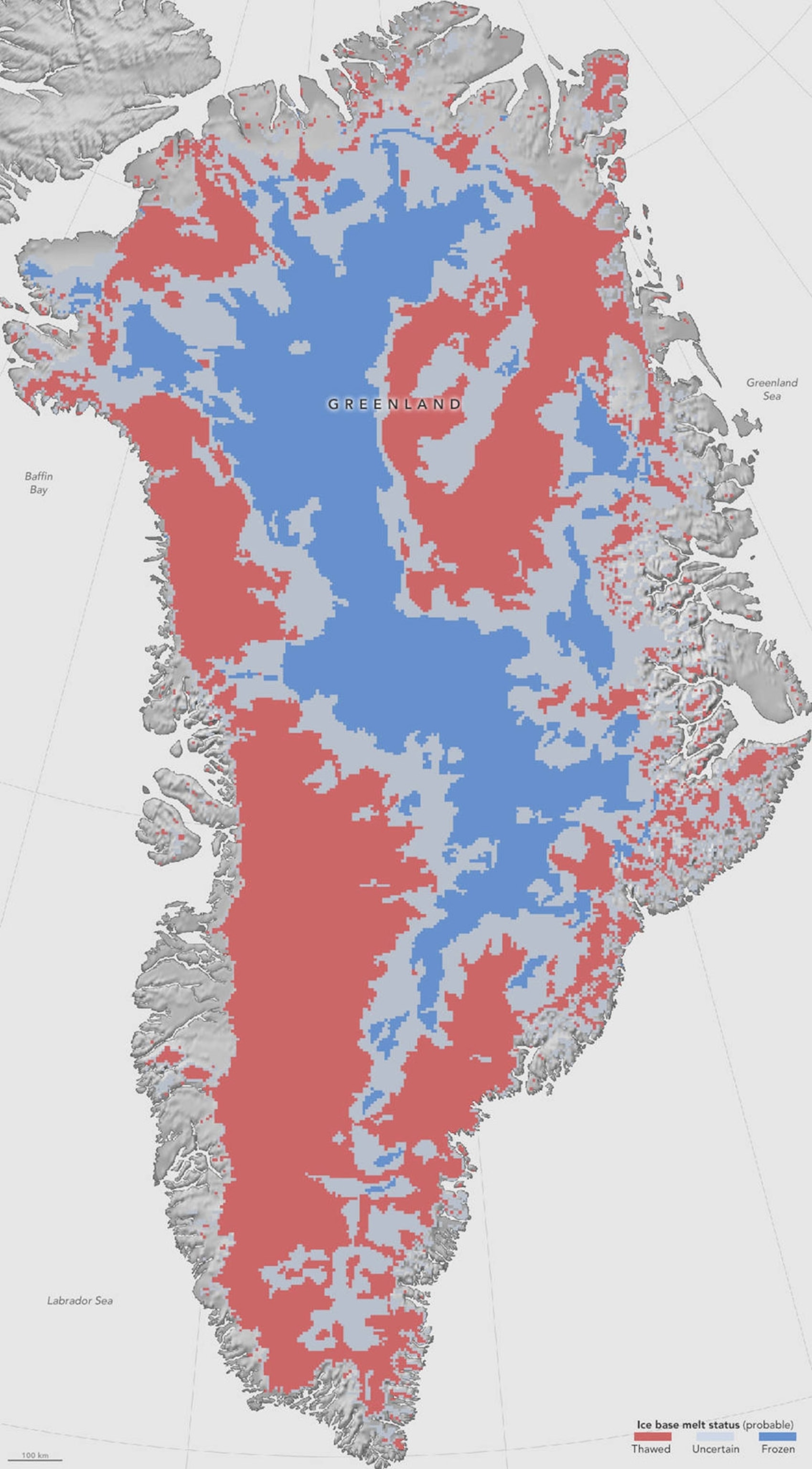
Another team, led by NASA glaciologist Joe MacGregor, studied the bottom of the ice sheet to see which parts are frozen and which have thawed. Knowing this is critical to estimating how fast the ice can flow, and how quickly it will change in response to warming temperatures. The scientists combined ice-penetrating radar data with satellite measurements and eight computer models of the ice sheet to create a new map (pictured above), published in July in the Journal of Geophysical Research—Earth Surface, showing where the bottom of Greenland’s ice sheet is frozen and where it is wet.
The thick layer of ice covering the island insulates the ground from the frigid temperatures above. At the same time, heat from the Earth’s interior warms the ground from below. In some areas, the ice is firmly anchored to frozen ground. But in other areas, particularly around the thinner edges of the ice sheet, the base has thawed and the ice is sitting on wet earth. If there is enough water underneath, the ice will flow more quickly, which could speed melting and affect how quickly sea levels might rise.
In another study, MacGregor’s team used the ice-penetrating radar to look inside Greenland’s ice sheet and map how it has moved over time. The radar works by sending signals into the ice and recording the strength and timing of all the reflected signals. Each layer of ice reflects the radar differently due to different thicknesses and other characteristics such as the amount of atmospheric dust incorporated into the ice. Using the different reflection signals, scientists can make a map of all the buried layers of ice.

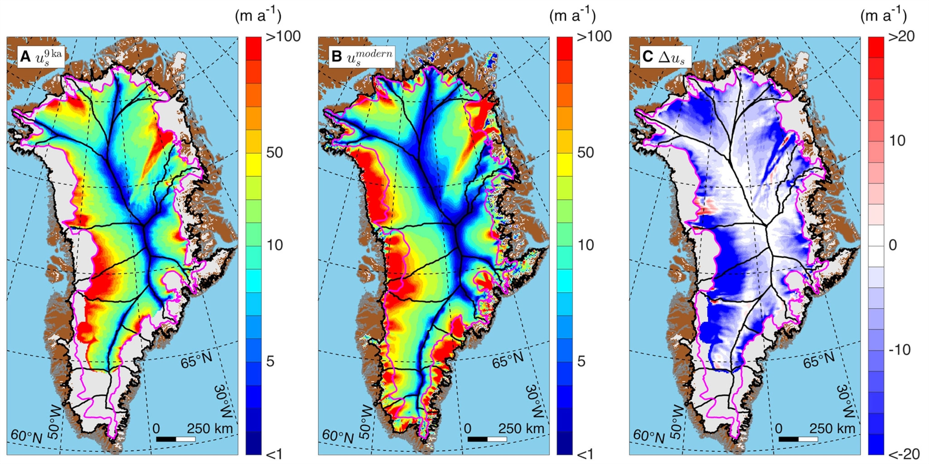
For this study, published in February in Science, the researchers analyzed the layering to see how the ice has flowed over the last 9,000 years. This lets scientists know how the ice behaved under previous climate conditions, which then helps them predict how the ice will behave in the future. What they found was a surprise.
Despite the fact that Greenland’s ice is melting faster than it is accumulating, most of the ice sheet is actually flowing more slowly than it has in the past. The maps above show the deceleration. On the left is the average rate of flow of the ice sheet over the past 9,000 years (red is highest speed); the map in the middle shows the speed from 1995 to 2013; and the map on the right shows the difference between the two rates, with the blue areas showing deceleration.
The scientists suggest the slowing is due to the fact that the older ice is softer than new ice. The newer ice has formed a stiff cap that has slowed the rest of the ice down. The deceleration combined with an increase in snow accumulation has actually allowed the center of the ice sheet to thicken. Unfortunately, this doesn’t change the fact that overall, Greenland is losing ice and the melting is accelerating around the edges of the ice sheet. In fact, melting was at record pace in 2015.

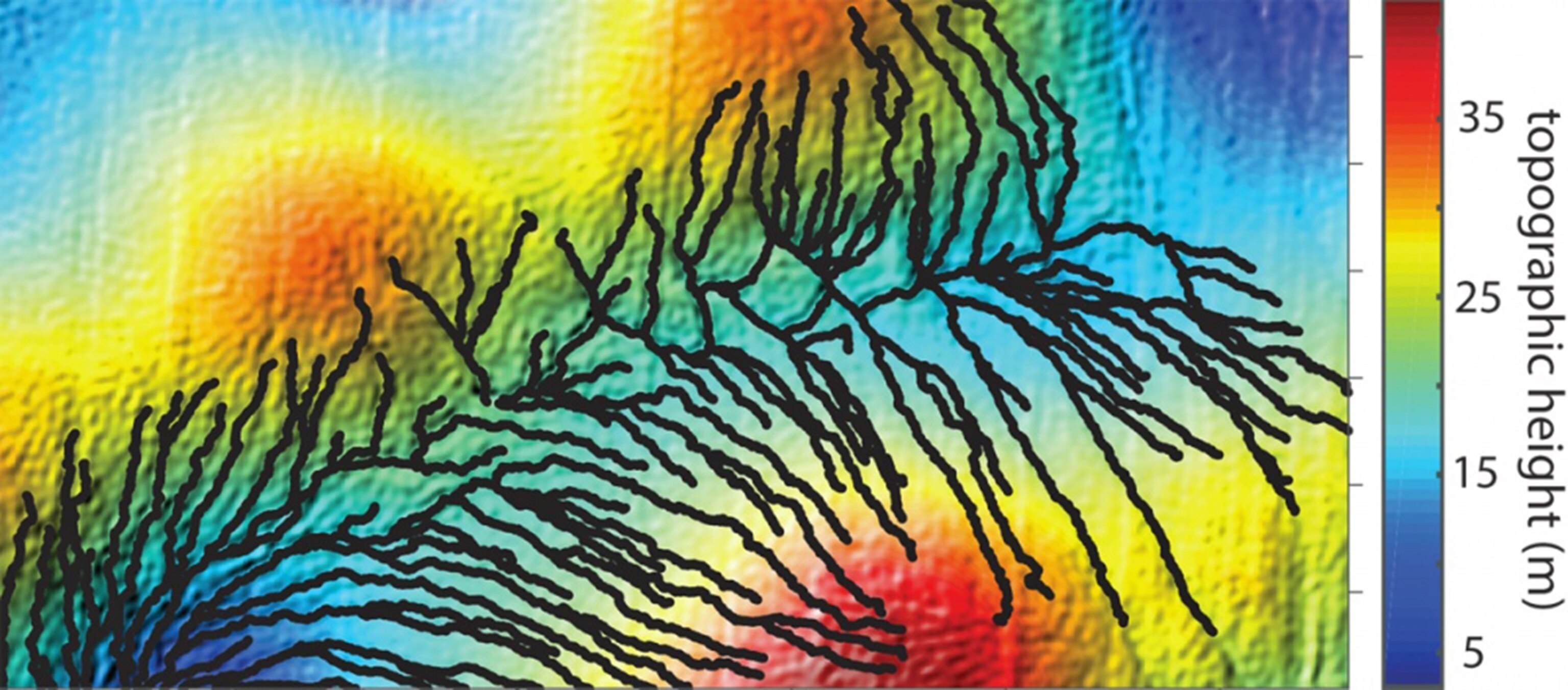
Scientists are also taking a closer look at the surface of Greenland’s ice sheets and glaciers. A study in March in Geophysical Research Letters looked at rivers that form meltwater on top of Greenland’s ice sheet in the summer. Scientists used digital elevation models to identify and map these rivers. The image above shows a network of them overlain on the elevation model.
The researchers discovered that the channel systems on top of the glacier look a lot like river drainage systems on land, and they evolve and erode the underlying topography in similar ways, but at much different timescales. They are similar enough that scientists may be able to use the fast-forming glacier channels to test ideas in real-time about how river networks on land form and behave.
Mapping the meltwater flow on glaciers will also help scientists understand how fast Greenland’s ice is melting and what its impact will be on sea level. Quantifying the melt rates of glaciers and ice sheets is tricky because they vary so widely from season to season, but the new work suggests researchers may be able to use the different geometries of supraglacial river systems to quickly diagnose how fast a glacier is melting.
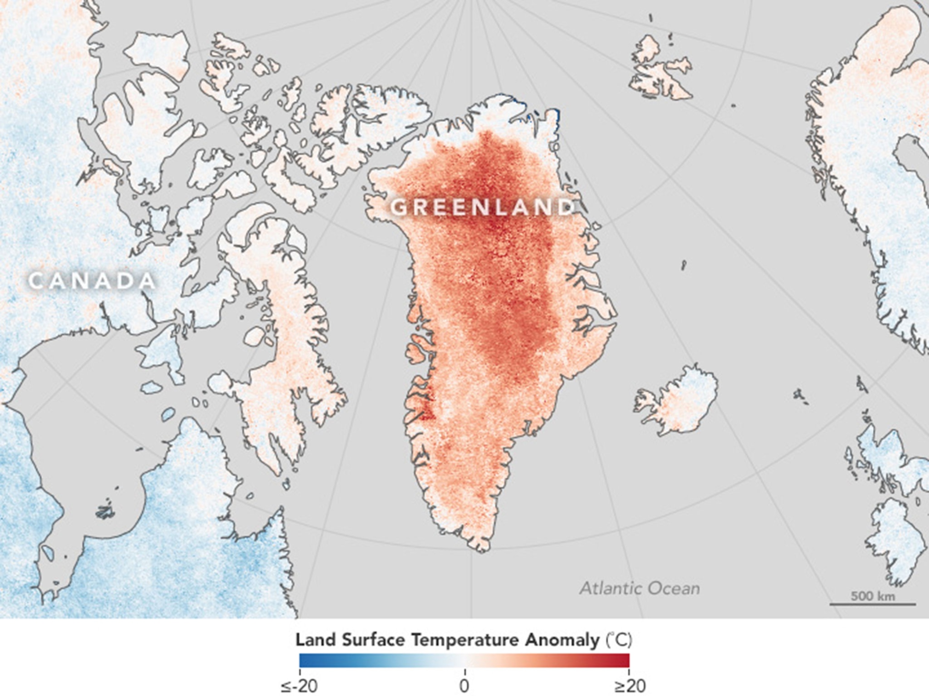
With hotter temperatures and record melt rates affecting the island, now is the time to understand how Greenland’s ice is moving and melting. The map below shows how much warmer Greenland’s ice sheet was in April this year relative to the average April temperature from 2001 to 2010.
