A Spy, a Map, and the Quest for Power in 16th-Century Europe
In 1502, as Europeans hungrily looked to the vast new continent across the Atlantic Ocean, innovative maps of these unfamiliar territories became objects of power and intrigue. Alberto Cantino, an Italian spy, acquired a Portuguese map showing stunning finds in the New World.
Knowledge is power—and no knowledge was more assiduously coveted by European nations in the early 16th century than the information recorded on nautical maps. Coastlines, harbors, rivers, resources: Details about these features could give a nation a distinct advantage in trying to stake a claim to new lands.
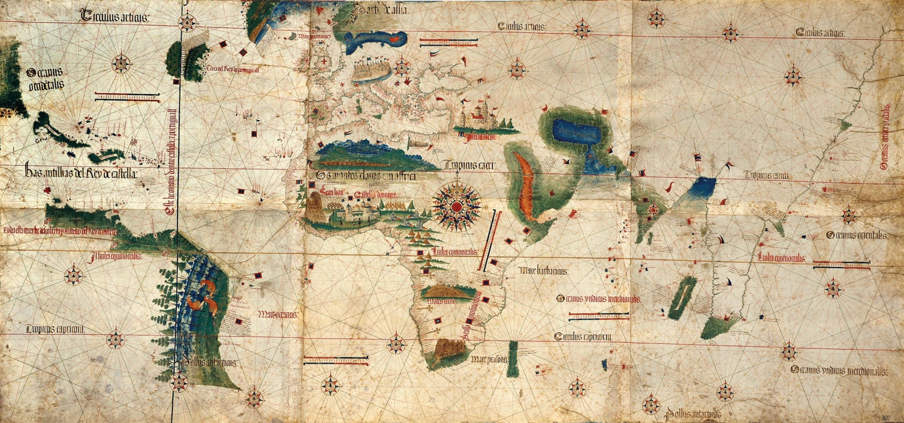
The “Cantino Planisphere,” completed in 1502, is the second known chart to have depicted the New World. It included unpublished information on Portuguese trade routes and the ongoing discovery of the coastline of modern-day Brazil. At a time when knowledge of new territories lent expanding nations great strategic and commercial superiority, such maps were guarded as state secrets. Spies would do anything to get their hands on them.
Comprising six pieces of parchment attached to a large canvas measuring about four by eight feet, the “Cantino Planisphere” was created in Lisbon. The word “planisphere” means a sphere represented as a plane (i.e., a flat surface) and is more typically used to describe star charts.
It is named for Alberto Cantino, who was working in Portugal as an undercover agent of Ercole I d’Este, the Duke of Ferrara, a powerful city-state in northern Italy. Historical accounts differ as to how Cantino acquired the map. According to one version, he contracted a well-connected mapmaker to sneak into a Portuguese repository of nautical charts and compile the information he gleaned to create this map. Other historians argue the map already existed, and Cantino used Ferrara’s considerable wealth to buy it. Whichever way the map was acquired, records show that Cantino paid a hefty price for it: 12 gold ducats, a large sum at the time.
Putting It Together
Mapmakers of this age were faced with a colossal task: to unite extensive oral and written sources into a single image. Created a year or two before Cantino’s map, the earliest known depiction of the New World was made by Juan de la Cosa, a colleague of Christopher Columbus. Both maps reveal the great challenge the New World presented to mapmakers, who were still relying on centuries-old cartographic traditions.

Medieval maps were usually constructed using a wind rose (a diagram showing the frequency, strength, and direction of different winds), from which lines emerged depicting different routes. This information was suitable for coastal navigation; when equipped with a compass, navigators could rely on the coastline as a visual reference.
Transatlantic navigation, of course, meant leaving the coastline behind, and Cantino’s map testifies to a key moment in cartography: the transition to astronavigation. The first map to include the Equator, tropics, and the Arctic Circle, the “Cantino Planisphere” is also the first map to show the “Tordesillas line,” running north to south, which set the border between Spanish and Portuguese territories. Portugal could claim lands east of this line, while Spain could lay claim to lands to the west.
Wealth of Information
The “Cantino Planisphere” reflects the attempts to pack a map with key political, cultural, and economic information. Illustrations of local wildlife appear on the map: gray Senegal parrots in West Africa contrasting with the colorful macaws depicted in South America. Colonial landmarks are also shown in West Africa, such as the castle of São Jorge da Mina, built in the 1480s by John II of Portugal, which grew into a major African trade hub.

The journeys of 15th- and 16th-century European explorers are depicted on Cantino’s map including Vasco da Gama’s first voyage in search of a sea route to India (1497-99) and the “discovery” of the Brazilian coast in 1500 by compatriot Pedro Álvares Cabral (although some historians argue the Spaniard Vicente Yáñez Pinzón got there first). The information gathered from Columbus’s most recent voyages in the West Indies is seen on the planisphere, as well as is the coastline of modern-day Venezuela.
It is the first map to name the Antilles, the archipelago consisting principally of modern-day Cuba, Puerto Rico, Jamaica, Haiti, and the Dominican Republic. A thumblike peninsula to the north of Cuba is thought by some historians to be the first depiction of modern-day Florida despite Juan Ponce de León’s being credited as the first European to have reached it—11 years after the planisphere was made.

Fittingly for a document chronicling voyages, the planisphere itself would be subjected to a series of perilous journeys after Cantino acquired it. In 1592, it was taken from Ferrara to the Italian city of Modena. By this time it was very much an artifact, its contents out of date, but the map was still considered valuable.
In the mid-19th century the planisphere was stolen, only to be found a few years later hanging on the wall of a butcher’s shop in the city. Today it is safely conserved in the collection of Modena’s Galleria Estense, a magnificent reminder of Europe’s first efforts to chart the world as they were coming to know it.


