
Amid Superstorm Sandy's Havoc, A Win for Wildlife
A year after Hurricane Sandy smashed into the U.S. East Coast, some of the beaches and ocean areas are better for birds and marine life.
Hurricane Sandy's waves arrived at high tide, destroying 650,000 homes, flooding lower Manhattan, and inundating coastal wetlands. In a few places, however, the storm's fury appears to have wrought positive changes in the landscape.
In one Long Island bay, it turned the tide on decades of increasing pollution.
"Bellport Bay was as far as you could get from an inlet to the ocean, so it had the worst water quality," says Charles Flagg, a marine scientist at New York's Stony Brook University. "Now that's changed."
When Sandy made landfall on October 29, 2012, millions lost power and at least 147 people were killed. One year later, some communities are still rebuilding from the storm, the second-most costly hurricane to hit the U.S. since 1900, with damage of more than $50 billion.
Marshes, beaches, and wetlands also suffered. On Thursday, October 24, U.S. Secretary of the Interior Sally Jewell rolled out a $162 million plan to help 45 federal wildlife sites recover from the storm.
But amid the devastation caused by Sandy are a few places where the storm has improved wildlife habitat.
Better Bird Beaches
On the National Park Service's Rockaway beaches, part of New York's Gateway National Recreation Area, vegetation has been encroaching for years on nesting grounds for shorebirds, forcing them to nest closer to the surf, where flooding and high tides threaten the nests.

"Shorebirds need sand to build their nests, not too close to the water and not too close to vegetation," says Hanem Grace Abouelezz, a National Park Service biologist. "Our big concern is with the piping plover, which is a federal threatened species." (See "Hurricane Sandy Aftermath: What Happens to the Birds?")
On that October night last year, Superstorm Sandy ripped out 59 acres of beach grass and goldenrod on Rockaway's beaches, offering an almost 100 percent increase in shorebird nesting habitat. In 2012, NPS biologists reported that 54 percent of piping plover eggs were lost to flooding; in 2013, none were.
"Not only that, the storm scoured the sand and bared seashell deposits, which the birds prefer for nesting," says Abouelezz. The shells likely provide camouflage, confusing feral cats and other predators that hunt for shorebird eggs.
There are only 17 piping plover couples on the Rockaway beaches, so every egg counts. "They are very sensitive birds. They're just frail," Abouelezz says. "My house was knocked around pretty good by Sandy," she adds. "So, if I can see a bright side, anyone can."

Meadowlands Touchdown
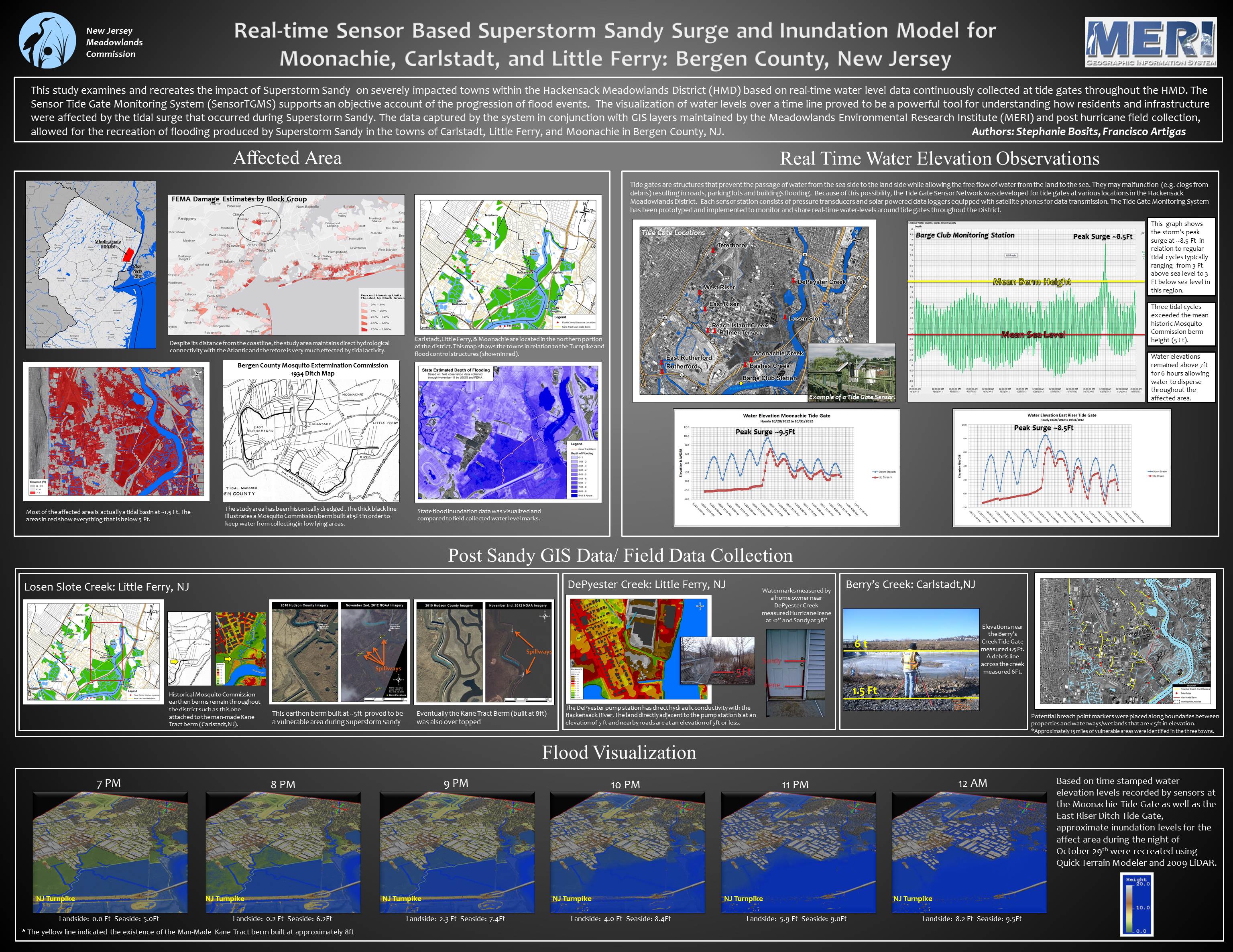
Off the coast, Sandy's surge overtopped five-foot berms and floodgates along the Hackensack River. A Meadowlands Environmental Research Institute report found complete inundation of wetlands as well as parts of several nearby towns, which saw some residents fleeing their homes in boats and dead fish littering parks.
But one year later, the dousing seems to have benefited the 8,400-acre (34-square-kilometer) Meadowlands, the reed-covered wetlands west of New York City famed for its long history of abuse at the hands of polluters and developers. (See "Swamps of New Jersey: The Meadowlands.")
"The storm actually moved a lot of debris out of the marshes that had been lodged there a long time," says Captain Bill Sheehan of Hackensack Riverkeeper, a private advocacy group for environmental cleanup of the region. The junk, lumber, trash, and reeds piled up five feet high in places along the New Jersey Turnpike, according to news reports.
"That really opened up a lot of the marshes for new growth," Sheehan says. Dirt and sand piled into some ponds that had been widening, he adds, filling them with sediment that served as a seedbed for fresh marsh grass stands.
"Nature moves things around," Sheehan says. "Wetlands are meant to handle those changes. Towns aren't."
Fire Island Surprise
Nowhere did Sandy move things around more dramatically than on Fire Island, a barrier beach between the Atlantic Ocean and Long Island's Great South Bay. Sandy blasted three breaches in the barrier islands along the south shore. Two of them were immediately filled in by the Army Corps of Engineers, as mandated by a Breach Contingency Plan put in place in 1997 by New York State's Department of Environmental Conservation (NYSDEC).
The third breach, across from the town of Bellport, was within the federally protected Fire Island National Seashore. Responding to the pleas of south shore residents, who blamed the breach for increased flooding in the months following the storm, politicians from Suffolk County Executive Steven Ballone to U.S. Senator Chuck Schumer called for that inlet to be closed as well.

