GPS is Tracking West’s Vanishing Water, Scientists Surprised to Learn
Scientists discover that GPS can measure how much water has disappeared from the West. It’s a bucketload.
Throughout the western United States, a network of Global Positioning System (GPS) stations has been monitoring tiny movements in the Earth's crust, collecting data that can warn of developing earthquakes.
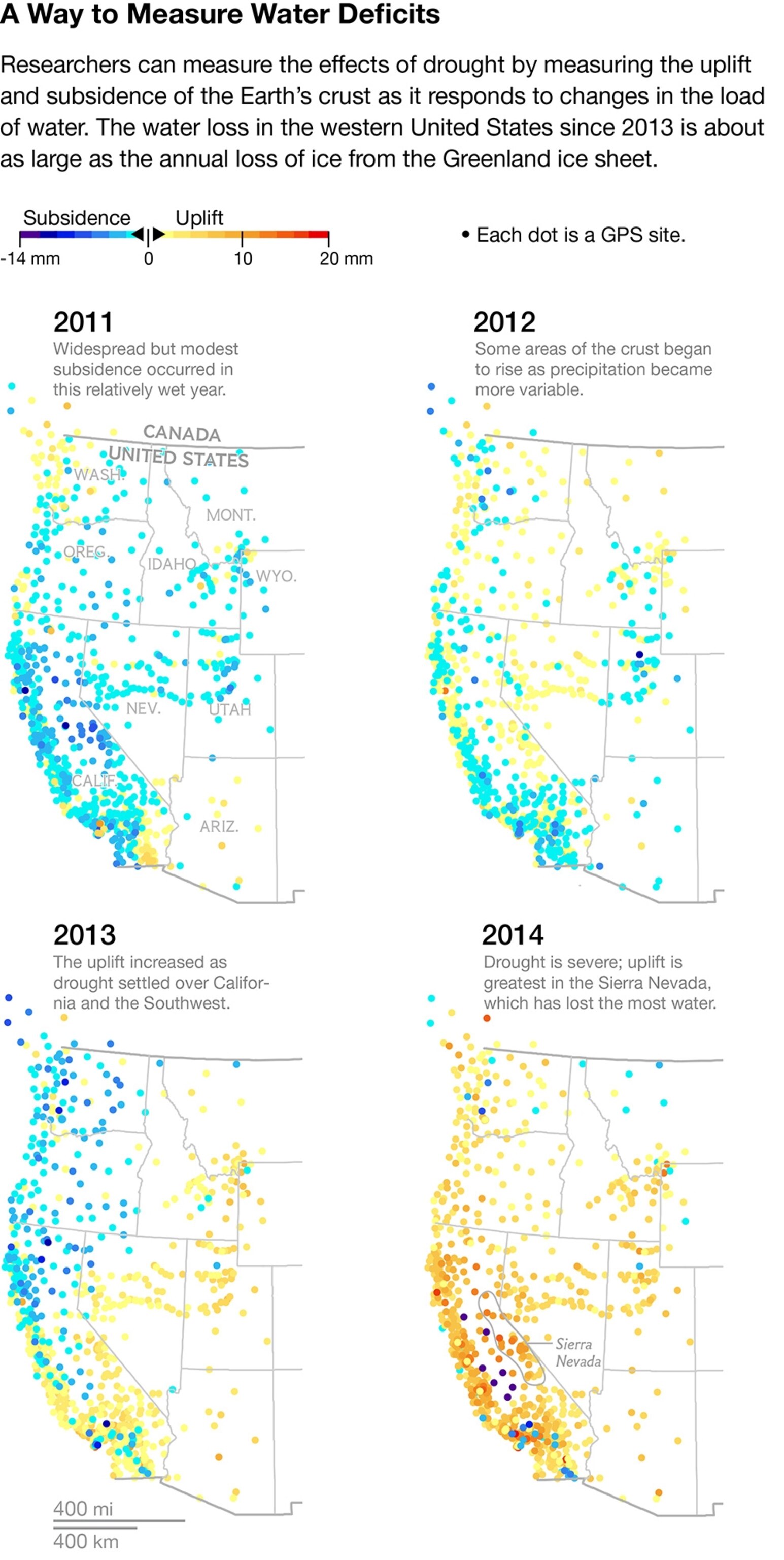
To their surprise, researchers have discovered that the GPS network has also been recording an entirely different phenomenon: the massive drying of the landscape caused by the drought that has intensified over much of the region since last year.
Geophysicist Adrian Borsa of the Scripps Institution of Oceanography and his colleagues report in this week's Science that, based on the GPS measurements, the loss of water from lakes, streams, snowpack, and groundwater totals some 240 billion metric tons—equivalent, they say, to a four-inch-deep layer of water covering the entire western U.S. from the Rockies to the Pacific. (Related: "Water's Hidden Crisis"
The principle behind the new measurements is simple. The weight of surface water and groundwater deforms Earth's elastic crust, much as a sleeper's body deforms a mattress. Remove the water, and the crust rebounds.
As the amount of water varies cyclically with the seasons, the crust moves up and down imperceptibly, by fractions of an inch—but GPS can measure such small shifts. (Related: "California Snowpack Measure Shows No End in Sight for Drought")
Borsa knew all this when he started to study the GPS data. He wasn't interested in the water cycle at first, and for him the seasonal fluctuations it produced in the data were just noise: They obscured the much longer-term geological changes he wanted to study, such as the rise of mountain ranges.
When he removed that noise from some recent station data, however, he noticed what he describes as a "tremendous uplift signal"—a distinct rise in the crust—since the beginning of 2013. He showed his findings to his Scripps colleague Duncan Agnew.
"I told him, 'I think we're looking at the effect of drought,'" Borsa remembers. "He didn't believe me."
The Dry Land Rebounds
But Borsa was right. As he, Agnew, and Daniel Cayan of Scripps report in Science, the recent uplift spike is consistent across the U.S. West, and consistent with recent declines in precipitation, streamflow, and groundwater levels. With a great weight of water removed, the crust is rebounding elastically across the whole region.
The median rise across all the western GPS stations has been four millimeters, just under a sixth of an inch. But the Sierra Nevada mountains, which have lost most of their snowpack, have risen 15 millimeters—nearly six-tenths of an inch.

The GPS data complements satellite observations from NASA's ongoing Gravity Recovery and Climate Experiment, or GRACE. The GRACE satellites measure small changes in the Earth's gravity field caused by the movement of water on and under the Earth's surface, allowing researchers to estimate groundwater and soil moisture conditions around the world. GRACE can operate where GPS networks don't exist—much of Africa and South America, for instance.
But where it's available, as in the western U.S., GPS data can provide a more rapid and detailed picture of drought and its causes.
"We only see the big picture," says Stephanie Castle, a water resources specialist at the University of California, Irvine, and the lead author of a recent study that used GRACE data to quantify groundwater loss in the Colorado River Basin. "The uplift data can point out more specifically where the depletion is happening."
Where the Water Goes
This new precision has big political implications: With more than 99 percent of California still in a severe drought, and rights to its surface water severely overallocated even in a good year, many of the state's farmers are supplementing their water supplies by pumping more water from underground aquifers.
In the Central Valley so much groundwater has been extracted that the ground has subsided more than 30 feet in some places—swamping the much smaller regional uplift caused by the elastic rebound of the underlying crust.

California has some of the weakest groundwater regulations in the nation, and access to its well-drilling records is highly restricted. The GPS data isn't detailed enough to point fingers at individual farmers, but its 125-mile resolution is good enough to identify especially profligate regions.
As climate change worsens water stress throughout the American West and beyond, such knowledge may well be vital. Borsa and his colleagues started out trying to filter the noise of the water cycle out of the GPS data; they ended up showing that the GPS network could help reveal what's really going on with water.
"All of a sudden we've turned the whole thing around," Borsa says. "It's a huge change, and it makes the network useful to whole new branches of scientists and managers."
Follow Michelle Nijhuis on Twitter.