As Hagupit Nears Philippines, Here's What You Need to Know About Typhoons
For starters, nearly 90 percent of these big oceanic storms are called typhoons and cyclones, not hurricanes.
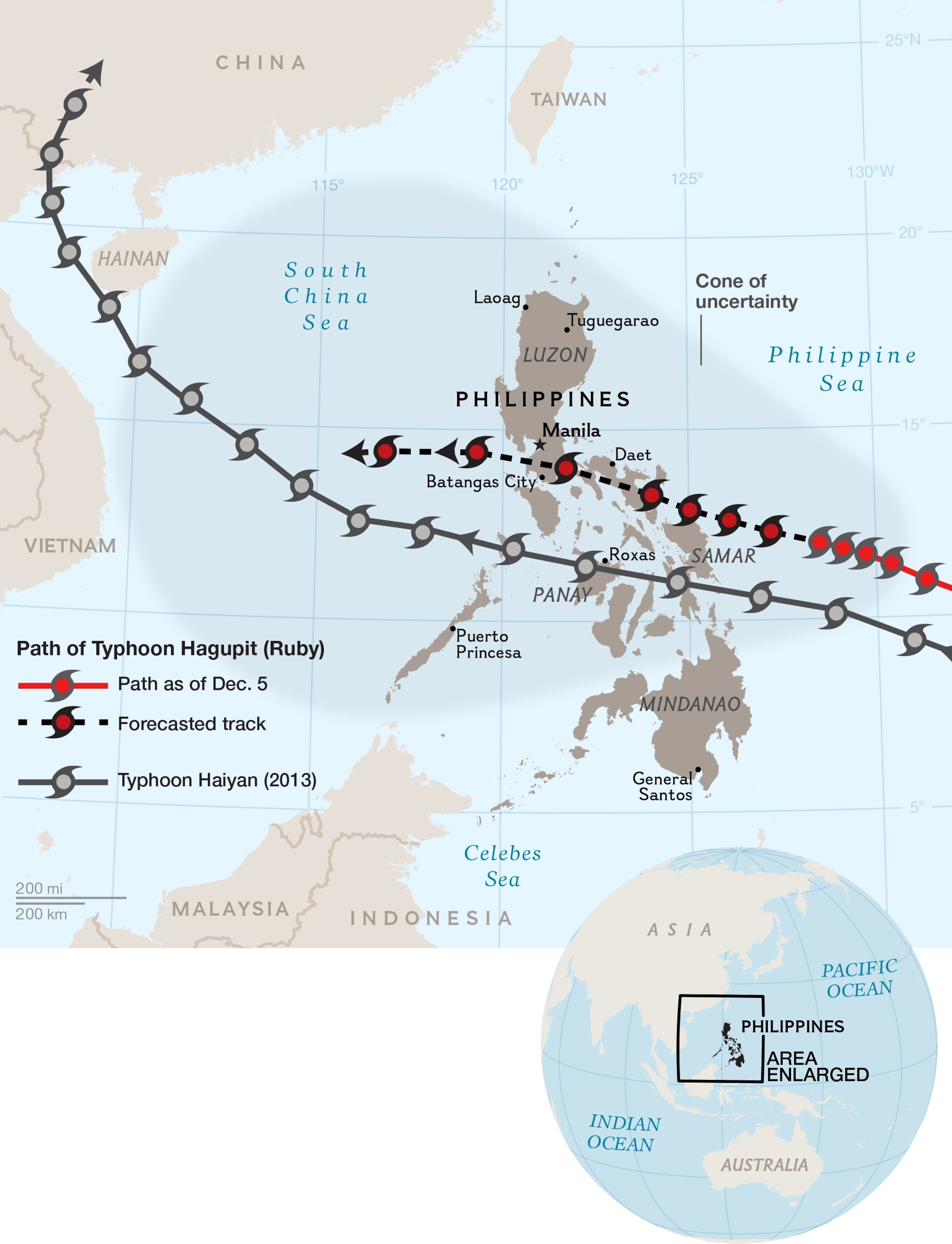
Update: Hagupit made landfall Saturday at 9:15 p.m. local time near the town of Dolores on the southeastern Philippine island of Samar. The storm—downgraded from its supertyphoon status—plodded ashore as a category 3, with estimated winds around 127 miles (204 kilometers) per hour.
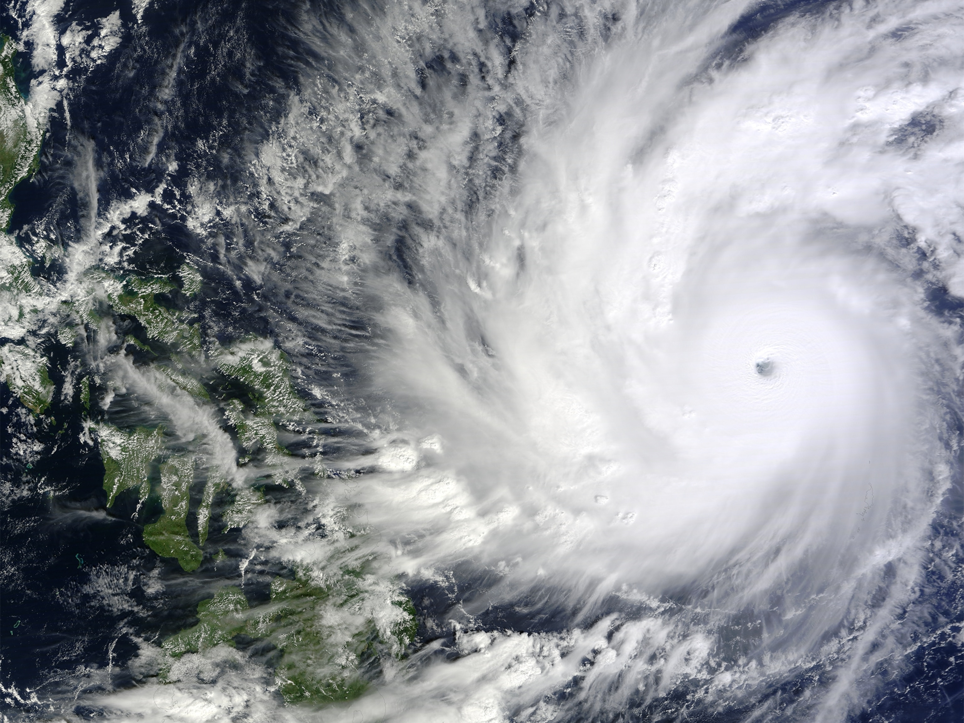
With a "supertyphoon" named Hagupit bearing down on the Philippines, you may be wondering: What's a typhoon?
Don't be afraid to ask. Hurricanes, typhoons, and cyclones are all just names for the same kind of devastating storm. But, as in real estate, how much attention they receive depends on location, location, location.
The tempest dominating the news right now is now lashing the Philippines. Hagupit, known in the Philippines as Ruby, was a strong category 4 storm with sustained winds of 150 miles (241 kilometers) per hour as of Friday.
The Philippines is no stranger to these violent storms. Typhoon Haiyan struck the country last November, washing away buildings, ripping up vegetation, and killing over 6,000 people. (Read about why the Philippines is so disaster-prone.)

The storms that rage across the western Pacific Ocean are called typhoons, while the ones spawned in the Atlantic and eastern Pacific are called hurricanes. Those born in the south Pacific and Indian Ocean are known as cyclones.
Collectively, hurricanes, typhoons, and cyclones are known as "tropical cyclones."
And here's a surprise for people in the Western Hemisphere: Only about 11 percent of these storms occur in the Atlantic, said Kerry Emanuel, an atmospheric scientist at the Massachusetts Institute of Technology in Boston. The rest occur in the Indian and Pacific Oceans. Atlantic hurricanes just happen to get the most press.
These storms form essentially the same way, but there are some differences. While the Atlantic has a defined hurricane season, for instance, typhoons can form at any time in the western Pacific.
There are some times of the year, however, when the western Pacific region is more active, said Howard Diamond, director of the World Data Center for Meteorology in Asheville, North Carolina, part of the U.S. National Climatic Data Center. Summer and early fall tend to see more typhoons, but "December is not out of the question," he added.
This is because the western Pacific Ocean is essentially a standing pool of warm surface waters, and that warmth fuels these kinds of storms.
Keeping the Motor Running
No matter where these spinning behemoths occur, they all need the same things—an atmospheric disturbance to generate storm clouds, surface ocean temperatures above 80°F (27°C), and very little vertical difference in atmospheric wind speeds.
Beyond that, scientists are still trying to understand what triggers them, MIT's Emanuel said. The storms continually generated off the coast of West Africa would seem to be ideal for hurricane genesis. "[But] only a small minority of those triggers a hurricane," he added.
Researchers know more about what keeps the motor running once a tropical cyclone gets started: the evaporation of water into the atmosphere.
Warm ocean waters feed that evaporation, cooling the immediate area and sucking more heat to the center of the storm. This sets up a cycle that keeps running until one or more of several factors stop it.
Winding Down
In many cases, tropical cyclones are their own worst enemy. All their atmospheric churning translates to turmoil in the ocean, which can drag up cold seawater to the surface. That puts a damper on things. "A lot of hurricanes don't get as strong as they could because of this," Emanuel said.
Losing their pool of warm water due to landfall is also the reason tropical cyclones weaken when they come ashore.
A third component that can put a stop to these fierce storms is wind shear. Upper atmospheric winds bring drier air into the center of a hurricane, which is "like throwing cold water on a fire," said Emanuel. "It just throttles the whole engine back."
What Makes a Deadly Storm
Tropical cyclones are categorized based on the wind speeds they generate, but that isn't typically the most dangerous part of such storms. "It's the storm surge," said Emanuel—that bulge of water built up in front of a cyclone courtesy of its winds.
It's the number one killer in hurricanes, he added. "That's what killed people in Katrina; it's what killed people in Sandy and in Haiyan." (See pictures of the recovery after Haiyan.)
Haiyan's storm surge went as high as 25 feet (7.6 meters). The Philippine Atmospheric, Geophysical, and Astronomical Services Administration predicts Hagupit's storm surge will reach about 13 feet (four meters) high.
MIT's Emanuel likened a storm surge to a tsunami—one just happens to be caused by earthquakes (tsunamis), while the other is generated by hurricanes.
Flash flooding caused by intense rains is also a major killer, Emanuel said. "Hurricane Mitch [in 1998] killed 12,000 people, and it was all from flash flooding."
Hagupit's Potential, and Beyond
Flooding rains are a particular concern for the Philippines as Hagupit slowly makes its way over the country, according to reports in the Washington Post. The snail's pace of the storm could mean that rainfall totals reach up to two feet (0.6 meter) in some areas.
Then comes the wind that blows around debris. Hurricane Andrew in 1992 is an example of the destruction wrought by wind. "[The hurricane] didn't really cause too much of a storm surge," the atmospheric scientist said, "but, boy, did it blow a lot of buildings down."
The worrisome thing in all of this, though, is that climate change will likely increase the frequency of "the high-end hurricanes," Emanuel said, those categorized as 3 or above (the scale tops out at 5).
These powerful storms produce a lot more rain—which increases the flood potential, he said. They also tend to generate strong storm surges. When stronger storm surges ride on top of rising sea levels, who knows what can happen?
Follow Jane J. Lee on Twitter.