
Hidden underwater landslides pose new dangers in the Gulf of Mexico
Seismic data show that earthquakes more than 600 miles away can trigger submarine mudslides that threaten offshore oil rigs and could lead to catastrophic spills.
Human error has caused some of the most infamous oil spills in U.S. history, such as those from the Exxon Valdez and Deepwater Horizon. But natural causes can also trigger epic disasters: A spill that has been gushing crude oil for 16 years started when an oil production platform off the coast of Louisiana was demolished by an underwater landslide.
Now, evidence from seismic data suggests these undersea avalanches are more common in the Gulf of Mexico than previously recognized, raising concerns about the region’s nearly 2,000 offshore oil platforms as well as tens of thousands of miles of oil and gas pipelines that transport fossil fuels to shore.
The analysis, published today in Geophysical Research Letters, shows that between 2008 and 2015, 85 previously unknown submarine landslides occurred in the Gulf. Ten of these, the study found, occurred without any detectable trigger. To the researchers’ surprise, the other 75 appear to have been set off by distant earthquakes—mostly small to mid-size tremors that occurred hundreds of miles away along North America’s west coast.
“I didn’t expect landslides would be that prevalent in the Gulf of Mexico,” says lead author Wenyuan Fan, a seismologist at Florida State University. “And I didn’t know landslides are so susceptible to dynamic triggering caused by passing seismic waves. I constantly tried to prove myself wrong.”
A seismic mystery in the Gulf
Scientists long have known the Gulf of Mexico has a history of submarine landslides. The largest underwater slump ever documented along any U.S. coastline occurred off the shore of Texas. Scars from other big landslides are visible on the seafloor near the mouth of the Mississippi River.
Researchers also have a good idea of why this terrain is so prone to collapse: Every year, rivers dump huge amounts of sediment into the Gulf, causing this loose material to pile up quickly on the seafloor and create steep, unstable topography.
But most of the Gulf landslides geologists have cataloged via seafloor mapping surveys occurred thousands of years ago. These events can’t tell us much about the frequency of undersea landslides today, or what exactly sets them off.
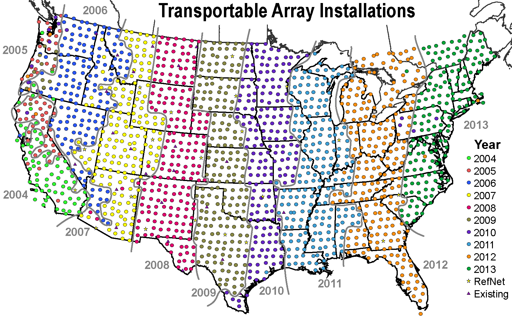
Fan and his colleagues have started to fill these knowledge gaps using data from the USArray, a network of 400 seismographs that migrated west to east across the continental United States between 2007 and 2013, collecting data for several years in each location. The project aimed to “turn America into a natural laboratory” and improve scientists’ fundamental understanding of how earthquakes work, Fan says.
The seismic data collected by the network doesn’t just reflect earthquakes. Many other earth-shaking events can trip a seismometer, which picks up waves at Earth’s surface, as well as faster-moving P and S waves, which travel through deeper solid rock.
Shortly after Fan started using some of the array’s data to study earthquakes off the Pacific Northwest in late 2017, he began spotting signals in the Gulf of Mexico, where very few quakes occur. After analyzing the properties of these waves and building models to recreate them, Fan and his colleagues became convinced they were looking at the seismic footfalls of submarine landslides—lots of them.
In data collected continuously between 2008 and 2015, the researchers identified surface waves associated with 85 distinct underwater landslides in the Gulf. Most startling to the team, almost 90 percent of them occurred within minutes of an earthquake that had taken place more than 600 miles away.
Most of these earthquakes occurred along the boundary of the Pacific and North American tectonic plates, between the Pacific Northwest and Mexico. Many of them were only around magnitude 5 in strength—minor enough that in California, “reporters would not even report” them, Fan says.
These observations, combined with the fact that more powerful, distant earthquakes didn’t produce detectable landslides, suggests to Fan that earthquake strength might not be the main factor that determines whether a landslide occurs in the Gulf. Fan stresses that more research is needed to elucidate exactly how remote earthquakes are toppling undersea ridges in an ocean basin hundreds of miles away.
“And that calls for an offshore experiment to unravel all the physical mechanisms that can cause submarine landslides,” he says.
U.S. Geological Survey seismologist Joan Gomberg, who served as an independent peer reviewer on the paper, says that geologists often use sediment deposits from undersea landslides as evidence of past earthquakes.
“But the whole premise of interpreting these is that the earthquake happened nearby,” she says. “What [Fan’s] work shows is the earthquake that causes them can be quite far away. So that kind of complicates how we interpret these records.”
A “worst-case” spill
Fan’s findings have implications beyond historical earthquake reconstruction. They suggest that oil and gas platforms and pipelines peppered across the Gulf of Mexico may face a geologic threat they are ill-equipped to handle.
“It’s not impossible that a platform could be destroyed by a mudslide. That’s already happened,” says Ian MacDonald, a professor of oceanography at Florida State University who wasn’t involved with the new study. “It’s not impossible that could trigger an oil spill that would be extremely difficult to control. That’s already happened.”
MacDonald is referring to the Taylor Energy oil spill just offshore of Louisiana, where crude has been gushing into the ocean at a rate of around a hundred barrels a day since 2004. Despite not being well known, this spill is considered one of the worst oil disasters in U.S. history. The cause? An undersea landslide triggered by powerful waves and storm surge from Hurricane Ivan.
In 2019, MacDonald published an article in The Conversation warning of the potential for another such disaster and calling it “the worst-case scenario for an oil spill catastrophe.” While the BP Deepwater Horizon oil spill was caused by a single well failure, in the case of the Taylor Energy oil spill, an entire platform was toppled by mud, causing multiple wells to fail and leaving oleaginous wreckage buried beneath a thick layer of sediment, where the leaks are difficult to access and plug.
Fan read MacDonald’s article and reached out to him, starting a dialogue that would lead to “a number of fruitful conversations,” MacDonald says. Reviewing Fan’s data on recent Gulf of Mexico landslides, MacDonald realized the risk to fossil fuel infrastructure was potentially far greater than he had appreciated.
“Over the last 10 years, we can [now] point to many of these events,” MacDonald says. “Which means to one extent or another, we’ve been dodging bullets, without even knowing that the bullets were fired.”
Fan is hoping his research will help energy companies and regulators make more informed decisions about where new infrastructure can be built safely. He notes that the majority of undersea landslides his team detected occurred in the western Gulf, a region that was largely off-limits for oil and gas exploration under the Obama administration but which President Trump began to open for business in 2018.
The seismic detection method Fan developed might also be retooled to create an early warning system that can safeguard existing infrastructure. If an array of seismographs were installed on the Gulf of Mexico seafloor to listen for landslides, companies could be alerted whenever a signal was recorded in their rig’s neighborhood, affording them precious minutes to implement emergency shutdown procedures.
With such a system, it’s possible an oil disaster could be stopped before it starts.
