National Geographic Logo - Home
    Paid Content for Japan National Tourism Organization
    Image of Tamasudare Falls, Yamagata, Tohoku, Japan
    • Travel
    • News

    Unveiling Tohoku, Japan's deep north

    Diverse cultures, deep history and magical landscapes await the curious traveler.

    The dynamic 200-feet cascade of Tamasudare Falls reverberates with a thunderous energy, in contrast with the otherwise serene woodlands.
    Photograph courtesy Tohoku Japan
    ByLisa Wallin
    Published December 15, 2021
    • 9 min read
    This is Paid Content for Japan National Tourism Organization. The editorial staff of National Geographic was not involved in the preparation or production of this content.

    A different world awaits just a few hours away from Tokyo, a part of Japan that has historically developed almost independently of influence from the capital city. Six prefectures make up Tohoku—Miyagi, Fukushima, Iwate, Aomori, Akita and Yamagata—together they create a rich tapestry of cultures and landscapes that bind together Tohoku’s past and present.

    2:00
    Travel writer Lisa Wallin explores by train the varied and surprising landscapes of Tohoku shaped by the changing seasons. Drone footage in this video were shot with permission in accordance to the rules set in Japan for railway filming. Footage courtesy ©JR-East, Yuri Kogen Railway, Akita Nairiku Line as well as Akita, Aomori, Fukushima, Iwate, Miyagi and Yamagata Prefectures.
    Video by Nat Geo Creative Works

    A stepping stone to Japan’s north

    Miyagi Prefecture, flanked by the Zao mountains in the west and brilliant coastlines in the east, is the Tohoku region’s most populous prefecture. The city of Sendai, seat of the powerful Date clan in feudal Japan, remains an important cultural and logistical hub, connecting Tohoku and Tokyo. Close to the city center, Osaki Hachimangu Shrine stands as a proud reminder of that glorious past, with each carving ripe with detail and meaning. Founded in the early 17th century, this opulent structure is a rare example of architecture from the Momoyama period (1568-1600).

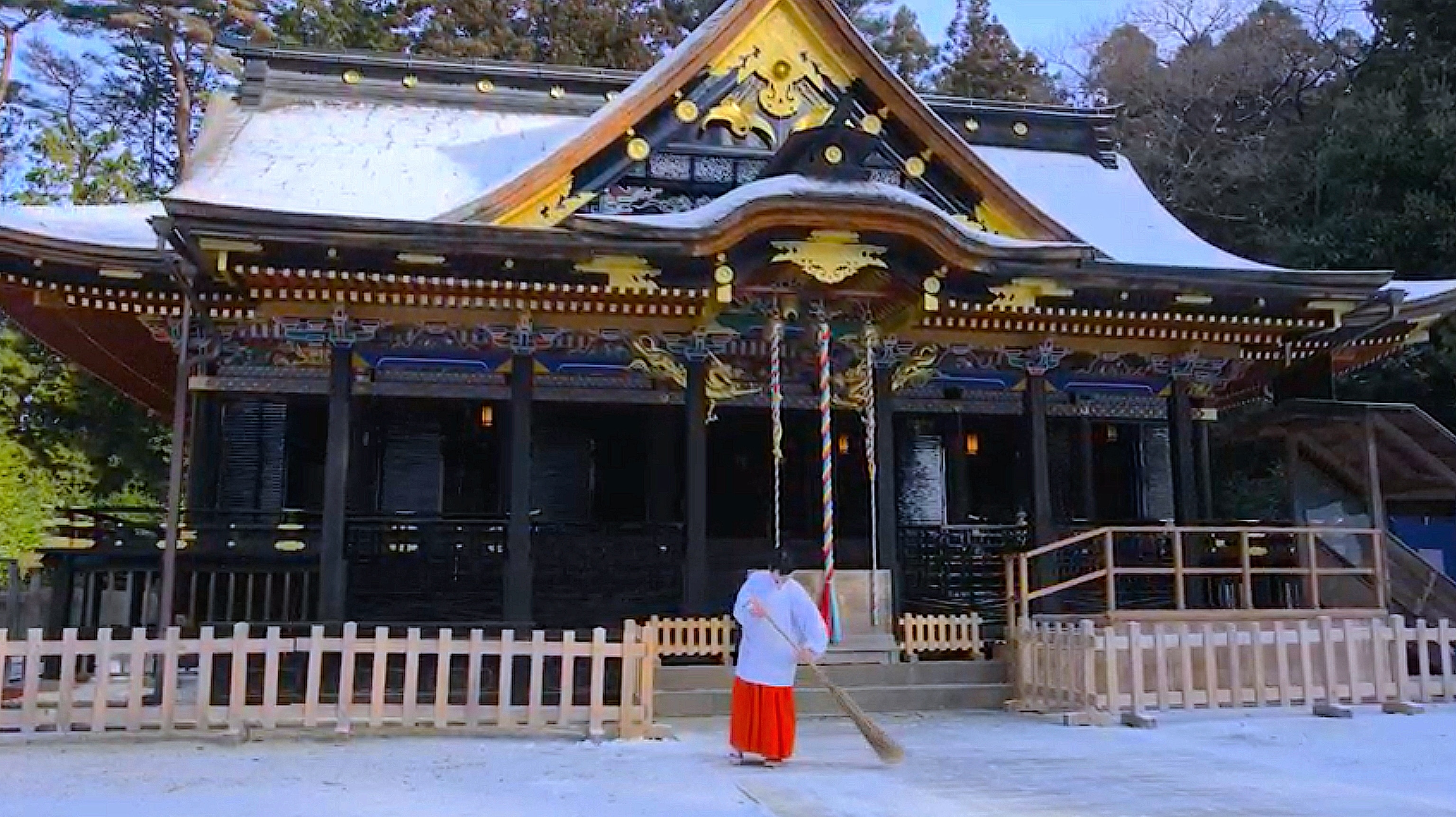
    Image of Osaki Hachimangu torri gates, Miyagi, Tohoku, Japan
    Please be respectful of copyright. Unauthorized use is prohibited.
    Image of Osaki Hachimangu temple, Miyagi, Tohoku, Japan
    Please be respectful of copyright. Unauthorized use is prohibited.
    Founded in 1607 and designated a National Treasure of Japan, Osaki Hachimangu Shrine remains an important place of worship to this day.
    Photographs courtesy Tohoku Japan

    Just a 40-minute train ride northeast of Sendai city lies Matsushima Bay, a place so beautiful it is said to have rendered 17th century haiku poet Matsuo Basho speechless. One of Japan’s three most scenic spots, the 260-odd pine-clad islets that dot the bay have drawn visitors to witness their beauty for centuries.

    Journey into the feudal past

    In the castle town of Aizu-Wakamatsu in Fukushima Prefecture, Japan’s feudal history can be sampled in Oyakuen Garden. A medicinal herb garden dating back to the early 1400s, visitors can sip on matcha at the teahouse while gazing over the pond, or amble through an estate of roughly 400 herb varieties that grow here.

    Image of Oyakuen Garden in Fukushima, Japan
    Converted from a 15th century villa, the teahouse pavilion of Oyakuen Garden was once used to serve visiting lords and important merchants in feudal Japan.
    Photograph by coward_lion / iStock
    Please be respectful of copyright. Unauthorized use is prohibited.

    Heading westward from Aizu-Wakamatsu, a train ride along the 84-mile Tadami Line traverses dense forests and sharp mountains where few outsiders dare to explore. Along this track is the breathtakingly picturesque No.1 Tadami River Bridge. Many photographers make the trip to Mishima-juku—arguably the best viewpoint along the Tadami Line—just to snap a photo of this iconic bridge.

    Image of No. 1 Tadami River Bridge, Fukushima, Tohoku, Japan
    Fukushima Prefecture’s Tadami Line is one of the most scenic railway routes in Japan.
    Photograph courtesy Tohoku Japan
    Please be respectful of copyright. Unauthorized use is prohibited.

    Breathtaking coastal corridors

    The craggy Sanriku coast along the eastern seaboard of Tohoku is flanked by the Sanriku Railway line, which spans 101 miles north to south from Kuji city to Sakari city. This is Japan’s longest local railway, offering spectacular views of Iwate Prefecture’s dramatic ocean cliffs and charming beaches.

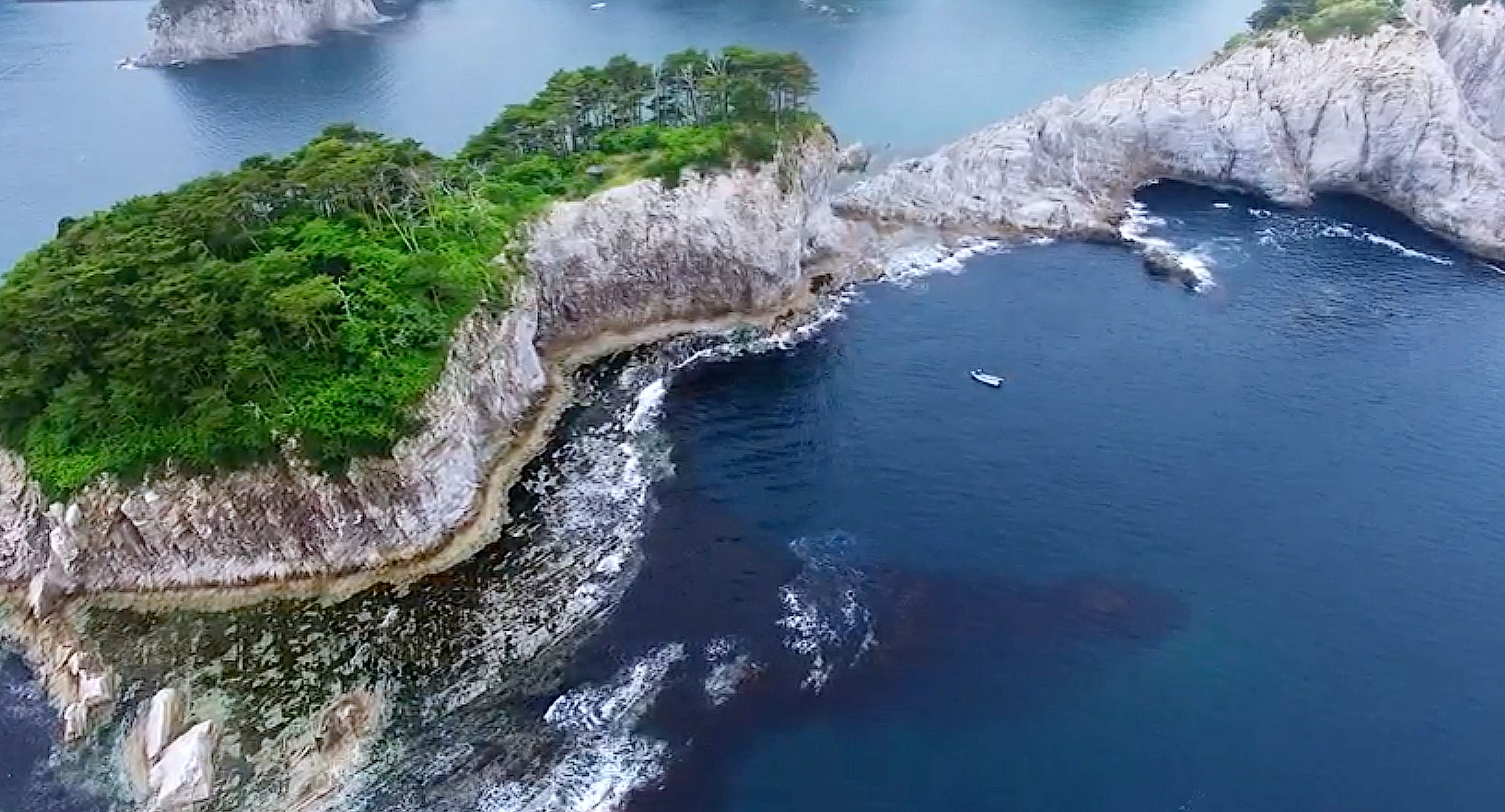
    Image of Sanriku Coast, Iwate, Tohoku, Japan
    Please be respectful of copyright. Unauthorized use is prohibited.
    Video still of Jodogahama Beach in Iwate, Tohoku, Japan
    Please be respectful of copyright. Unauthorized use is prohibited.
    Hugging the Pacific Ocean-facing side of Tohoku, Sanriku Coast features an extensive line-up of precipitous rock cliffs, salty sea caves, and gigantic sea stacks.
    Photograph courtesy Tohoku Japan (Left) and Photograph courtesy ©JR-EAST (Right)

    Along this route, you’ll find Jodogahama Beach in Miyako city. The shoreline here is a contrast of jagged white volcanic rocks, azure seas and almost-black pines. It’s no surprise 17th Buddhist monk Reikyo dubbed it “Pure Land Beach”, suggesting that it’s paradise on earth.

    The outdoors and the wild

    Lake Towada lies on the border of Aomori Prefecture, and it is the largest crater lake on Japan’s main island of Honshu. Over 1,000-feet deep and originally created by a violent volcanic eruption about 200,000 years ago, this dual caldera lake now peacefully mirrors the sky, mountains and beech tree forests that surround it.

    Image of Lake Towada in Aomori, Tohoku, Japan
    On a breezeless day, the waters of Lake Towada are so clear they can reflect the mountains, the sky and the trees.
    Photograph by Chen Min Chun / Shutterstock
    Please be respectful of copyright. Unauthorized use is prohibited.

    To the west, the Gono Line’s colorful Resort Shirakami trains connect Aomori and the neighboring Akita Prefecture, hugging the rugged west coast for much of the journey. Outside the wide windows, blossoming apple trees and a snowcapped Mount Iwaki transform into views of brave surfers battling the waves in sandy bays. On board, Tsugaru shamisen musicians strum furiously at the three-stringed thick-necked instrument with an infectious energy.

    At Senjojiki Station, you’ll find a 7-and-a-half-mile stretch of raised green tuff bedrock that the station is named after. The bedrock made its first appearance in 1792, when it rose from the sea after an earthquake. Senjojiki means one thousand tatami mats, and it memorializes a time when an 18th century feudal lord spread out hundreds of mats here for a banquet.

    The warmth of nature and the welcome of its people

    Tucked away in Akita Prefecture’s southeast corner, hot steam billows from the crevices at Oyasu Gorge, creating pearls of condensation that smell faintly of sulphur. Make the most of this potent gift from Mother Nature and stay at a nearby inn to envelope yourself in the soothing mineral-rich waters that bubble forth.

    Image of snowfall in Oyasu Gorge, Akita, Tohoku, Japan
    In winter, the pairing of steam and snowfall sets the stage for a magical wonderland at Oyasu Gorge.
    Photograph by yspbqh14 / Shutterstock
    Please be respectful of copyright. Unauthorized use is prohibited.

    Glancing out the window on an Akita Nairiku Line carriage offers visions of central Akita’s open fields and tree-topped hills. A stop at Kaminiokai Station offers an opportunity to connect with locals at the Wakuwaku Market, where they sell seasonal fare, handmade crafts and are happy to teach you a word or two in their dialect.

    0:05
    Perched on a clifftop, Nokyodo Hall and the neighboring Kaisando Hall of Risshakuji Temple, overlooks the picturesque Tachiya River Valley.
    Video courtesy Japan National Tourism Organization

    A blend of the past and present

    In Yamagata Prefecture, an arduous trek up 1,015 stone steps awaits those who visit Risshakuji Temple. It’s commonly known as Yamadera, which translates to mountain temple, because of its location on a precipitous cliff. It was first founded in 860 AD and used as a training temple for monks. Those who brave the journey to Kaisando Hall, a temple structure that teeters over the edge of a sheer rock face, are rewarded with panoramic views of the verdant valley below.

    Image of Risshakuji Temple, Yamagata, Tohoku, Japan
    The stone steps to Risshakuji Temple are lined with Buddhist sculptures, protecting visitors as they pass through.
    Photograph courtesy Tohoku Japan
    Please be respectful of copyright. Unauthorized use is prohibited.

    Further west in the coastal Shonai region, Shonai Hotel Suiden Terrasse is a newer Yamagata landmark. Constructed in 2018, the hotel ties together local customs, food and stories as seamlessly as it infiltrates its natural surroundings, ensuring its connection to the region’s past and present.


    Read This Next

    • Paid Content

    Tohoku awaits: the wonders of northern Japan

    • Paid Content

    A hiker's guide to Japan

    Take a picturesque walk through three UNESCO World Heritage Sites.
    The secret life of sake, Japan’s national obsession
    • Travel

    The secret life of sake, Japan’s national obsession

    From boisterous bars in Tokyo to bucolic breweries in the hinterlands beyond the capital, sake is intertwined with this island country’s cultural and spiritual life.
    Unlocking the mystery of Japan’s perfect paper
    • Travel

    Unlocking the mystery of Japan’s perfect paper

    Eco-friendly and adaptable, washi made the traditional way still thrives in towns steeped in history.

    Legal

    • Terms of Use
    • Privacy Policy
    • Your US State Privacy Rights
    • Children's Online Privacy Policy
    • Interest-Based Ads
    • About Nielsen Measurement
    • Do Not Sell or Share My Personal Information

    Our Sites

    • Nat Geo Home
    • Attend a Live Event
    • Book a Trip
    • Buy Maps
    • Inspire Your Kids
    • Shop Nat Geo
    • Visit the D.C. Museum
    • Watch TV
    • Learn About Our Impact
    • Support our Mission
    • Nat Geo Partners
    • Masthead
    • Press Room
    • Advertise With Us

    Join Us

    • Subscribe
    • Customer Service
    • Renew Subscription
    • Manage Your Subscription
    • Work at NatGeo
    • Signup for Our Newsletters
    • Contribute to Protect the Planet
    • Pitch a Story

    Follow us


    National Geographic Logo - Home

    Copyright © 1996-2015 National Geographic SocietyCopyright © 2015-2023 National Geographic Partners, LLC. All rights reserved