Undersea Mysteries Mapped by Satellite Gravity Sensors
Space missions reveal hidden hills and buried rifts in the ocean depths.
Ancient rifts hide under seafloor sediments along with thousands of uncharted underwater mountains, satellite images revealed on Thursday.
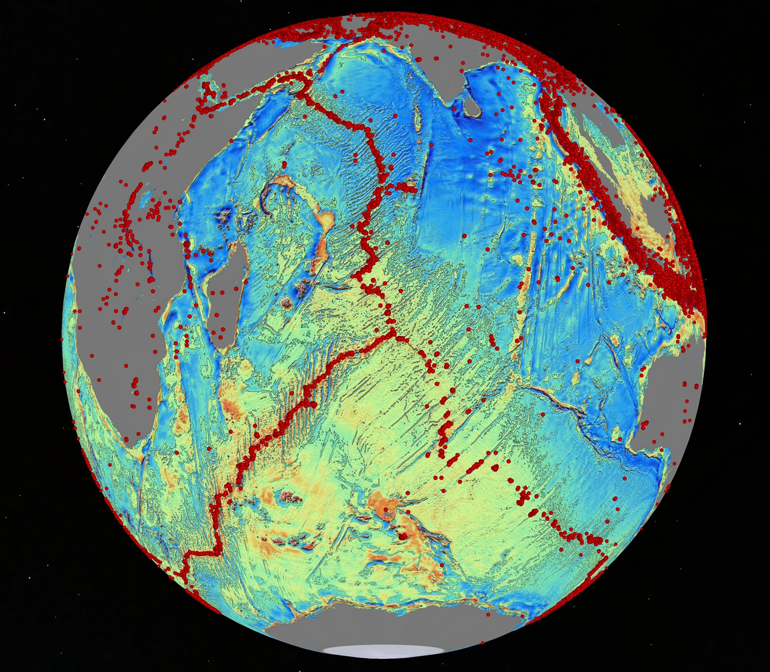
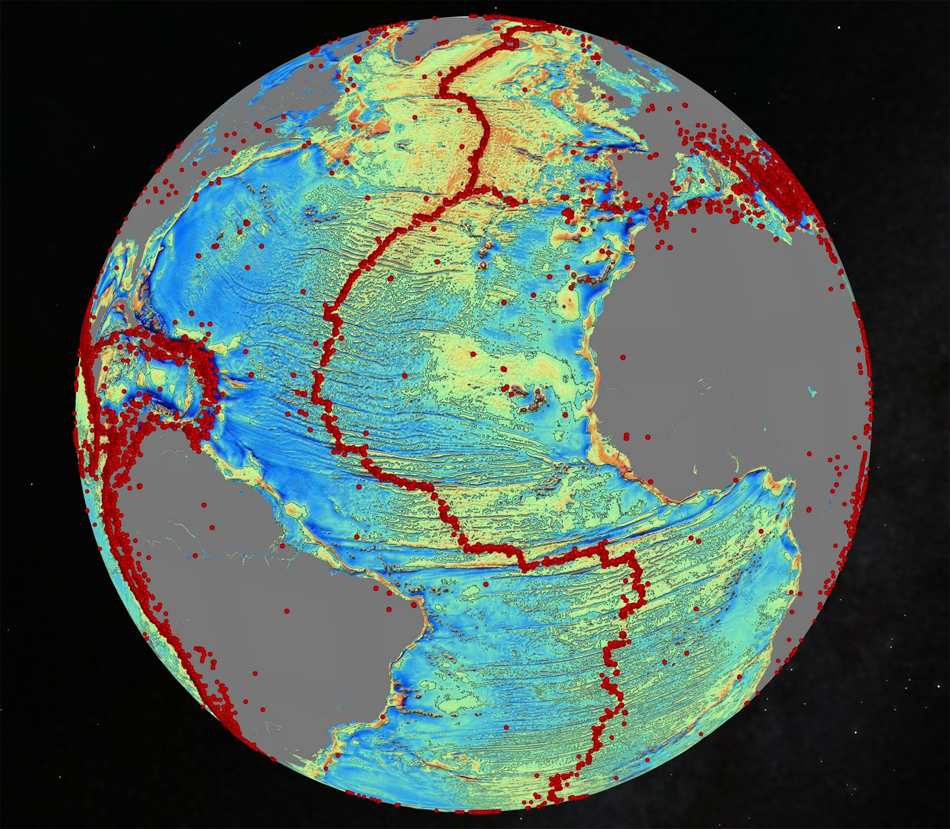
Most of the world's deep ocean remains poorly charted, as the fruitless search for the missing Malaysia Airlines Flight 370 in the Indian Ocean earlier this year showed. The new satellite images released by the journal Science map undersea features as small as three miles across (five kilometers) for the first time.
The satellites mapped much of the world's oceans, including the Gulf of Mexico, South China Sea, and South Atlantic.
"The only way to see ocean floor topography quickly and comprehensively is from space," says study lead author David Sandwell of the Scripps Institution of Oceanography in La Jolla, California. "Ships would take another 200 years to do this mapping, at present rates." (Read "Mountains in the Sea" in National Geographic magazine.)
Instead, the study found the hidden geography using two spacecraft, the European Space Agency's CryoSat-2 and NASA's Jason-1, both oceanography satellites that were designed to track sea-level changes.


Deep Gravity
To map the seafloor, the satellites detect ripples and dips in the ocean's surface. Ridges and seamounts, or undersea mountains, are massive enough to exert a gravitational pull that makes sea levels drop by as much as 3.9 inches (10 centimeters) above the feature.
Fractures and rifts in the seafloor, in contrast, elevate sea surface levels due to a reduced gravitational attraction above their depths.
Stitching together the pattern of these sea-level deviations, the study authors detected geological features that were hiding underneath the soft layers of sand and sediment coating the seafloor. The finds include:
—Several thousand seamounts roughly 0.6 to 1.2 miles (1 to 2 kilometers) high, previously unknown.
—Subsea ridges jutting at a southward angle from South America and Africa—the latter some 500 miles (800 kilometers) long and 62 miles (100 kilometers) wide—once joined but severed more than 83 million years ago by a spreading South Atlantic.
—An "extinct" ocean ridge stretching under the Gulf of Mexico where ocean crust once spread apart when it was tectonically active.
The maps are "a breakthrough in space-based marine gravity observation," say oceanography experts Cheinway Hwang of National Chiao Tung University in Taiwan and Emmy Chang of National Taiwan University, in a commentary accompanying the study.

Map Quest
About 80 percent of the world's ocean area has not been mapped using depth soundings from ships, the study notes. The seafloor features, and depths, revealed by the study serve as a starting point for remedying the problem, Sandwell says.
The results should aid geologists looking for undersea mineral resources and help to explain how deep-sea currents flow across the seafloor.
The CryoSat-2 satellite will continue to take sea surface readings from its 250-mile-high orbit (400 kilometers) for the next few years. With more data, the gravity maps could be refined to reveal hundreds of thousands of previously unknown seamounts less than 3,300 feet (1 kilometer) high dotting the ocean floor.
The one thing the maps won't do is reveal the location of missing airplanes, Sandwell says. "Of course we looked when the [Malaysia Airlines] plane crashed," he adds. But given the resolution of the gravity maps, "we think the gravity model will be very helpful for reconnaissance maps on future searches."
Follow Dan Vergano on Twitter.