How Tornadoes Form and Why They’re so Unpredictable
A look at storm science after severe weather kills in the Midwest.
More than 70 tornadoes were reported over the weekend in the Midwest and Great Plains of the United States, killing at least three people, with at least ten more still missing and significant damage in Arkansas and Texas.
More tornadoes are expected in the coming days. The fierce storms can happen at any time of year but are most common in May and June in North America, when atmospheric conditions tend to be most right for their formation. Tornadoes remain deadly and relatively unpredictable, despite recent advancements in weather science.
Here’s what scientists do know:
A tornado, or twister, is a violently rotating column of air that extends between the Earth's surface and a cloud, usually a cumulonimbus cloud. Most tornadoes last for less than ten minutes, says Harold Brooks, a research meteorologist with the National Oceanic and Atmospheric Administration's (NOAA) National Severe Storms Laboratory (NSSL) in Norman, Oklahoma.
Large tornadoes usually last longer—around 30 minutes, Brooks says. The most powerful twisters have wind speeds of more than 300 miles (483 kilometers) per hour, which can rip buildings off their foundations. They can be more than two miles (3.2 kilometers) wide, and can spin across the ground for dozens of miles.
The more common tornadoes have wind speeds of less than 110 miles (177 kilometers) per hour, are about 250 feet (76 meters) across, and travel only a few miles before they dissipate.
Tornadoes kill an average of 60 people a year in the U.S., mostly from flying or falling debris, reports NOAA. (See "Interactive: Forces of Nature.") Half of those deaths are caused by the strongest one percent of the most violent storms, says Brooks.
How Tornadoes Form
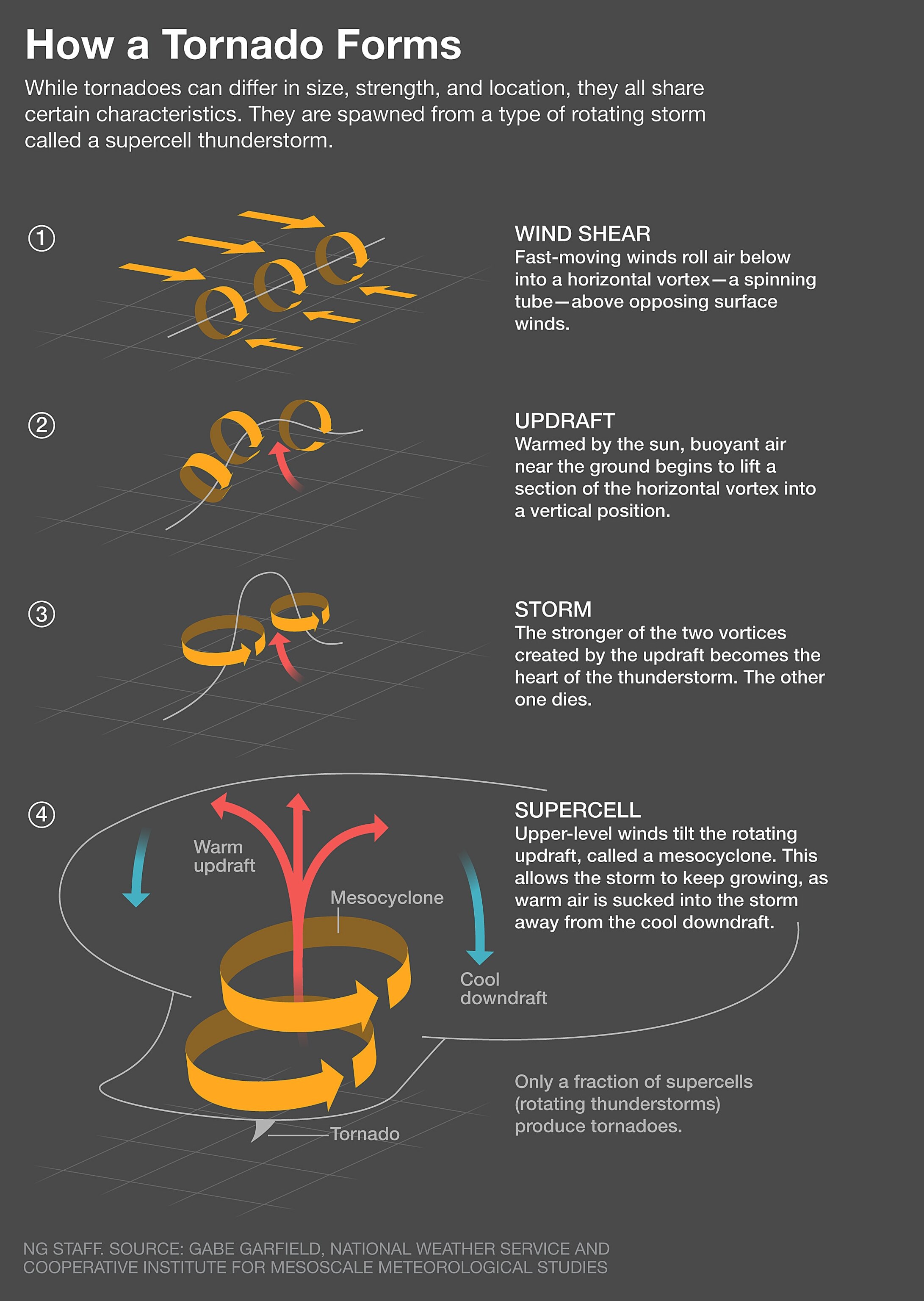
The most intense tornadoes emerge from what are called supercell thunderstorms. For such a storm to form, you first "need the ingredients for a regular thunderstorm," says Brooks.
Those ingredients include warm moisture near the surface and relatively cold, dry air above. "The warm air will be buoyant, and like a hot-air balloon it will rise," says Brooks.

A supercell requires more: winds that increase in strength and change direction with height. "Then the updraft tends to rotate, and that makes a supercell," explains Brooks.
The supercell churns high in the air and, in about 30 percent of cases, it leads to the formation of a tornado below it. This happens when air descending from the supercell causes rotation near the ground.
Even then, "we still don't know why some thunderstorms create tornadoes while others don't," tornado-chaser Tim Samaras said in early 2013. Samaras was a scientist and National Geographic explorer who was killed by a twister on May 31, 2013, in El Reno, Oklahoma. (Read about Samaras's life and death.) Brooks says scientists believe that strong changes in winds in the first kilometer of the atmosphere and high relative humidity are important for the formation of tornadoes. There also needs to be a downdraft in just the right part of the storm.
Indeed, tornado formation requires what Brooks calls a "Goldilocks" situation, in which air must be cold but not too cold. It should be a few degrees more frigid than surrounding air.
But there's more scientific mystery surrounding how tornados end. "We don't understand how tornadoes die," Brooks says. "Eventually the air gets too cold and it chokes off the inflow of new air into the storm, but we don't know the details."
13 striking pictures of extreme weather.
Where and When Twisters Strike
Tornadoes have been observed on every continent except Antarctica. They have been most documented in North America, where an estimated 1,200 strike the United States each year, but they frequently appear in many other countries. (See an interactive map of tornadoes in the U.S.)
The most notoriously affected region in the United States, called "Tornado Alley," includes the Great Plains states of Kansas, Nebraska, and the Dakotas, as well as parts of Texas. Large-scale weather patterns tend to converge on that area, making tornadoes more likely.
In many countries, including the United States, Canada, and continental Europe, the strength of tornadoes is measured by the Fujita scale or the updated Enhanced Fujita Scale. An F0 or EF0 tornado damages trees but substantial structures are left unharmed; a tornado in the strongest category—F5 or EF5 —blows away buildings.
Since measuring wind speeds inside a twister is extremely difficult, scientists typically rely on damage to estimate velocities.
The Difficulties of Forecasting
Tornadoes are much harder to forecast than hurricanes, which are larger storms that last a lot longer. According to NOAA, the average amount of time between a tornado warning and the arrival of a storm is about 13 minutes. (A tornado warning means a twister has been sighted, while a tornado watch means one is possible.)
The National Severe Weather Laboratory's Warn-on-Forecast research project is aiming to improve forecasting, but the work is slow-going.
The project uses powerful software to crunch data on temperatures, moisture, and other atmospheric variables. Sometimes the system "makes really good forecasts, and other times it doesn't," says Brooks.
As computers get faster and data improves, forecasts may get more accurate. In the meantime, better understanding of the atmosphere will also help other fields, such as planning for wind farms or the placement of solar panels.
Predicting the path of a tornado across the landscape can also be challenging. Brooks says tornadoes tend to follow the general movement of the thunderstorm they are associated with, but the route can be erratic.


