Three Cool Things We’ve Learned From NASA's Mars Gravity Map
The vibrant new map reveals Mars’ hidden geology and could help track the red planet’s seasonal swings.
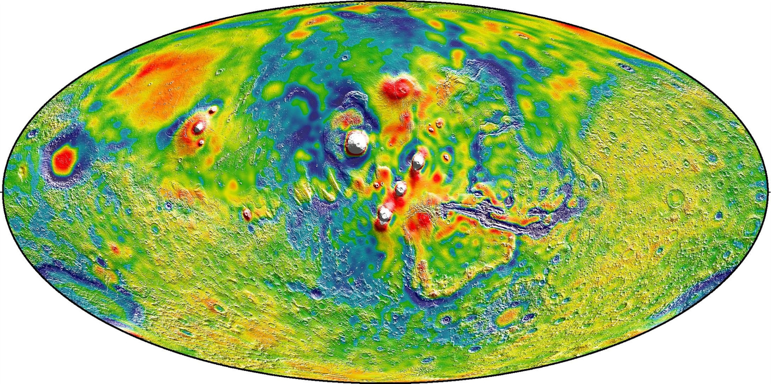
NASA has released a stunning new map of Mars that shows the planet’s terrain in a way not visible to the naked eye—using gravity to reveal new details about everything from the core to the atmosphere.
“It’s giving you a signal of the lumps and bumps of the planet’s surface,” says Richard Zurek of NASA’s Jet Propulsion Laboratory, who wasn’t involved with the mapping. “It’s pretty amazing that one can track this out from spacecraft flying 180 miles above Mars’ surface, through the wisp of the planet’s atmosphere.”
To reveal Mars’ gravitational wrinkles, MIT’s Antonio Genova and his colleagues analyzed 16 years’ worth of tracking data from three Mars satellites, looking for telltale wobbles in their positions and velocities caused by variations in the planet’s tug. The end result, published on March 5 in the scientific journal Icarus, tracks these extremely slight differences from the heights of the Olympus Mons volcano, the tallest in the solar system, to the depths of the Valles Marineris canyon system.
“It’s a really nice piece of work,” says Zurek, who says it will help shape the debate over Mars’ mysterious geological history. Here are the three things you need to know about the new gravity map, and the mysteries it could help solve:
Mars’ Carbon Dioxide Really Gets Around
Perhaps the study’s biggest finding is that gravity is an excellent weather-tracking tool.
By watching the fluctuating gravity of Mars’ frigid polar caps, Genova and his colleagues confirmed that during northern winter, up to 4 trillion tons of carbon dioxide freezes out of the atmosphere and piles up at the pole. The same thing happens at the southern pole during that hemisphere’s winter. This seasonal gas migration involves about one-sixth of Mars’ atmosphere by mass.
What’s more, the team was able to gravitationally track the planet’s CO2 cycle over 16 years, letting the researchers see how the solar cycle—the sun’s roughly 11-year rise and fall in activity—affected the gas’ movement. Their calculations largely match up with real-world measurements collected by rovers on the Martian surface.
“From our data—spacecraft that orbit about Mars—we’re able to measure the variation of the mass of the polar caps, and [this approach] basically can give us another view [of] how the climate on Mars evolved over the past billion years,” says Genova.
“Buried Channel” Theory Gets Buried
The new map also helps to explain a “gravity trough” that lies in Mars’ northern lowlands, between the Tempe Terra highlands and the Acidalia Planitia plains, the setting for the sci-fi book and movie The Martian.
Previous studies had identified the trough—a north-south patch of anomalously low gravity—as a huge waterway that once transported water and sediment but was later buried by the massive eruptions of Mars’ Tharsis volcanoes billions of years ago. The new analysis shows that the “trough” follows the geological boundary between Mars’ wildly different northern and southern hemispheres—revealing it to be a wrinkle in Mars’ crust created when the Tharsis volcanoes belched out enormous amounts of lava.
It’s not the only study to assign such a massive role to the Tharsis volcanoes: Recent work even proposes that the volcanoes’ eruptions shifted Mars up to 20 degrees on its axis as the planet got thrown off-balance by the additional surface mass.
Mars Definitely Has a Gooey Center
The new analysis wasn’t just skin deep: Using the same data, researchers could also see how much the sun and Mars’ moon Phobos gravitationally stretch the red planet. Confirming a landmark 2003 study, they found that Mars’s observed elasticity is best explained if the planet has a liquid outer core between 3,400 and 3,600 kilometers wide.
Inside Earth, a liquid outer core helps power the dynamo that gives our planet its protective magnetic field. Genova’s result might help clarify the tragic history of Mars’ magnetic field, which went from a full-fledged shield like Earth’s to nothing but a skin-deep residue on its southern hemisphere. Without a strong, planet-wide magnetic field, streams of particles flung off the sun could have more readily blown away much of early Mars’ atmosphere, destroying the planet’s ancient oceans—and perhaps dooming any nascent Martian life.
Mighty impressive, for a model based on three satellites’ subtle orbital wiggles.
Follow Michael Greshko on Twitter.


